Sunday, October 31, 2010

Ghoulish Google Maps

No Trick Treats

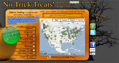
Here is a great idea to create a map of places that kids with dietary restrictions can visit when trick or treating.

The site lets treat givers add their addresses and the snacks they'll be giving out to a Google Map, and then it shows treat-getters the places in their area that have goodies that they can enjoy!

Ghostag

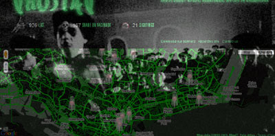
Ghostag is a crowd-sourced map of ghost sightings.

To tag a ghost on the map you simply need to click on a location and add the details of your sighting. If you manage to get a picture of the ghost (or failing that - the location of the sighting) you can also add that to the map.

The map uses the Google Maps API v3 Styled Maps function to create a suitably creepy look. When viewing the map turn on your speakers as it also contains some ghostly sounds and the occasional ghost like apparition appearing on top of the map.

Woooooo!

Zombie Reports

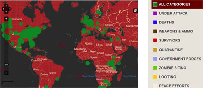
As a special Halloween dispensation I'll include this crowdsourced map of zombie sightings, even though it uses the hauntingly popular OpenStreetMap.

The site uses the Ushahidi report mapping system to map the spread of zombies around the world.

Haunted Los Angeles Map

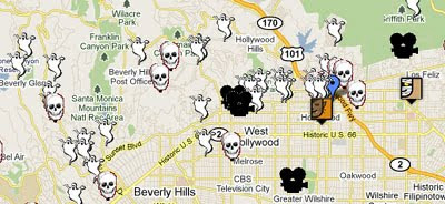
Creepy LA have produced this Google Map as a guide to reported supernatural activity throughout Los Angeles County.

Map of the Dead

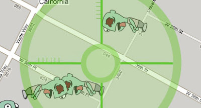
This old zombie shooting game from Google is still good fun. The game-play is very simple - you have one minute to shoot as many zombies as you can. Although I might be mistaken, the game seems to be taking place at the University of Southern California so those might be students and not zombies. Sometimes it's hard to tell the difference.


This post would not have been possible without geoparadigm's spooky Halloween Bookmarks

_____________

Saturday, October 30, 2010

18th Century Book Trade on Google Maps

Atlas of the Rhode Island Book Trade

The Rhode Island Historical Society are using Google Maps and the MIT Simile Timeline to map as many members of the Rhode Island book trade in the 18th Century as possible.

The data on the Atlas was derived from dozens of sources, ranging from maps and histories of Rhode Island towns to land records and court documents. If you scroll the timeline above the map then the map will load the relevant markers for that period of the 18th century.

The markers on the map show the location of printers and booksellers. If you click on a marker the information window explains when and where the member of the book trade was active. You can also click a link to access the full record in the database. Each marker also contains a precision rating that helps explain how precisely the marker is located.

_____________

Friday, October 29, 2010

Google Map of Schools & Pot Dispensaries

School-Pot Map

Marijuana policy is a hot topic in California right now. Proposition 19, which would legalise various marijuana-related activities, is being voted on next Tuesday.

In an effort to help inform voters School-Pot Map shows the walking distances from San Francisco public schools to the nearest marijuana dispensary. For example, Marshall Elementary is only 142.2 yards from the nearest dispensary.

The marijuana dispensaries and the school locations are based on data from the San Francisco Department of Public Health and the San Francisco Unified School District.

_____________

Friday Fun with Google Maps

Fartsquare

It looks like Foursquare could have a new rival.

Via: TNW

Strangely Shaped Road

What will those soccer hooligans get up to next? It appears that Google aren't fans of English soccer team Newcastle United as they have drawn a huge penis over their ground, St James Park.

Street View Mural


Street View Funny found this superb mural in Montpellier, France.

Via: Street View Funny

Area 51 - Google Reviews

If this review for Area 51 is anything to go by not everyone is happy with the service they receive at Area 51 in the USA. The text reads:

"Poorly treated. I found that on arriving from my home planet of Diuahdhajissiannsa I was brought to this horrible place. I was extremely mistreated and was often probed. Would not recommend."

_____________

Thursday, October 28, 2010

See How Cities Connect on Google Maps

Autobiopic CityLinks

Autobiopic is a Google Maps based tool to visualise your Foursquare check-ins. The application allows you to animate your recent check-ins on Foursquare and return the distance you have travelled.

Autobiopic has now developed a very cool visualisation tool called Autobiopic CityLinks. This new visualisation tool uses Google Maps to measure the connectivity between cities based on the number of visitors to Autobiopic who have checked into both of those cities.

If you enter a city into the search box you can view a map showing you the connectivity of Autobiopic users. The map shows where people from the city travel by drawing a line from a check-in made in the searched city to other cities that the Foursquare user has travelled to.

There are already 1,500 cities in the CityLinks database so you should be able to view a CityLinks visualisation for most of the major cities around the world.

_____________

Dutch Random Street View Locator

StraatBlik

Random location and Street View generators seem to be all the rage at the moment. Here's another one.

Straatblik generates a random Street View from Google Maps' imagery in the Netherlands. To move to the next random view just press 'Volgende'.

My first random find was what looks like the world's largest spinning top. What can you find?

_____________

Find a Job in Finland with Google Maps

Duunitori.fi

Duunitori.fi is a Finnish jobs search website that uses Google Maps to help users find jobs near their location.

Using the map users can search for jobs by location and by type. After you have entered your location and the areas of work you are interested in the resulting jobs are displayed on the map.

Duunitori.fi have devised their own clustering system which works very well. If you zoom out of your chosen location Duunitori.fi automatically loads more markers onto the map and can cope well with thousands of markers.

was developed by cloudingsky

Via: Esa

_______________________

Wednesday, October 27, 2010

Google Maps Collages

Jenny Odell's Satellite Collection

Graphic Designer Sarah Odell has created a series of beautiful digital collages using cut-out imagery from the satellite imagery on Google Maps.

The image above is made up of various cargo ships and other boats found on Google Maps. The other digital prints include collages of swimming pools, grain silos & water towers and square mile images from the Great Salt Lake.


Also See

  • Apres Garde - Beautiful images found on Google Street View
  • Lehel Kovács - Hungarian designer using Google Street View as the starting point for
  • cityscapes
  • Virtual Paintout - paintings inspired by Google Maps Street View
_______________________

Get on Your Bike with Google Maps

Cycling the Alps


Cycling the Alps is a Google Map with a lot of information and some very nice features for anyone who is interested in cycling the Alps.

If you right-click on any of the map markers you can view details about the selected mountain pass, view photogrpahs or videos, view a tour of the pass with the Google Earth browser plug-in, or post a comment.

Using the menu bar at the top of the map you can select to view passes by height, select layers showing webcams, Wikipedia, YouTube or Panoramio photos and you can even view camp-sites.

_______________________

Iraqi Civilian Deaths on Google Maps

Map of Iraqi Civilian Deaths on Familiar Locations

Mike Brennan has used the WikiLeaks Iraq War Logs to create a Google Map of civilian deaths in Iraq over a five year period.

The map uses the WikiLeaks data and Fusion Tables to show you the location of all the civilian deaths in Iraq. To help users get a little more perspective of what 65,649 deaths looks like you can overlay the data on maps of cities that you are familiar with.

For example, if you click on the New York City link you can view the same data transposed to the Big Apple:


The full list of cities that you can overlay the data on is: New York City, Washington, DC, Philadelphia, San Francisco, Los Angeles and Chicago.

Also See
_______________________

Weather Forecasts with Google Maps

The Weather Land - Global Forecast System

The Weather Land uses Google Maps to show the current weather at your location or for any chosen location around the world.

When you first visit Weather Land the application automatically detects your location and displays a custom precipitation map for your country. You can then click on the map to load cities in the map sidebar.

If you click on any of the cities in the sidebar the local weather forecast for your chosen location is displayed. The weather for the next three days is loaded showing the forecast temperature, wind and precipitation.

_____________

Tuesday, October 26, 2010

TweetDeck with Google Maps

TweetDeck for Android

TweetDeck the independent desktop client for Twitter is now available as an Android application with some pretty useful integration with Google Maps.

The TweetDeck application for Android, as you might imagine, allows you to send and read messages from Twitter directly from your smartphone. In addition the application is also integrated with Facebook, Foursquare and Google Buzz.

One of the niftiest features of the application is the deep location integration with checkins and venue details on Google Maps. The applications uses Google Maps to show you the tweets and check-ins around your current location. This allows the user to find nearby venues from Foursquare and read Foursquare tips about that venue.

TweetDeck also allows you to view the recent nearby check-ins of your Foursquare friends. Last week Max Howell, the developer of TweetDeck's Android application spoke at the London GeoMob.

Max spoke enthusiastically about the location features of the application, claiming that he now very rarely organises his social engagements. He now uses TweetDeck instead to find the venues his friends are currently frequenting to facilitate serendipitous social engagements.

_____________

Most Popular Baby Names on Google Maps

Baby Name Map

Guy Davis' popular Baby Name Map has been updated to include the latest popular baby names for 2009. The map has also extended its coverage to a large number of other countries.

The map allows users to find out popular baby names in different countries around the world. The map allows you to click on different countries and browse the top names for both boys and girls. For example, did you know that the most popular boy's name in Norway is Jonas? I wonder if any of them are bothers?

_____________

Finding Friends with Google Maps

ecocedu

This Russian website uses Google and Yandex Maps to show the locations of user submitted photographs and messages.

The most interesting feature of ecocedu is the mapping of user submitted messages. Anyone can choose a location on the map and leave a message about a 'neighbour'. Messages can be left to try and track down old friends. For example,

"My friend lived here in 1990. He was called ....... Does anyone know where he lives now?"

Using the map control buttons at the top of the map it is possible to view Google road or satellite maps or Yandex road and satellite map tiles.

_____________

Monday, October 25, 2010

Random Google Maps

geo.pick

Have you ever wanted to explore the world at random? Have no idea where to go for your next vacation? Or just want to discover what's out there? geo.pick helps you find places that you never knew existed.

geo.pick chooses a city and country at random from anywhere in the world and shows its location to you on Google Maps. It is possible to pick a random location from anywhere in the world or to get a random location from a chosen continent.

As well as showing you the random location on Google Maps geo.pick displays statistics about the city from the Finland World Database and images from Google Search.

MapCrunch - Random Street View

Do you feel lucky?

This fun Google Maps application displays a random Street View image from anywhere in the world. To view a random image from Street View all you have to do is press the 'Go' button.

If you want to narrow down the randomness of the image you can select to view only Street View imagery from particular countries. Each country with Street View imagery has its own button and each can be set to on or off. MapCrunch also offers the option to avoid country roads.

My favourite button however is the 'auto' button which allows the user to just sit back and watch as a succesion of random Street Views appear on your screen.

Google Street View Roulette

Street View Funny, the Street View Gallery website, created this Street View randomiser a while back now. Street View roulette is restricted to imagery from the UK. To play Street View Roulette just press the 'Random Google Street View' button.

_____________

Win Win with Google Maps

Go Uniqlo

Clothing Store Uniqlo are giving Malaysians three chances a day to win an item of clothing with this imaginative Google Maps game.

To play the game you need to create a clothing trail. To do this you simply need to enter a location. A trail will then be created from your location to Kuala Lumpur. The trail consists of a number of photographs of worldwide destinations and items from the Uniqlo range.

If you click on any of the items of clothing you can read details about the clothes and, if you are lucky, you might also find that you have won the selected item. Unfortunately for the rest of the world the game is only open to Malaysian citizens.

This isn't the first time Uniqlo have used Google Maps to promote its brand. Last year Uniqlo created a stunning video and Google Maps synchronisation. Unfortunately the map seems to have taken a dive into the dead-pool, but you can still watch this video of the map in action:


_______________________

Toronto's Transit Planners on Google Maps


TTC Trip Planner

If you live in Toronto you are lucky enough to have two public transit route planners, the TTC's own TTC Trip Planner and MyTTC. Both trip planners will help you plan the best route on Toronto's public transit system and display your route on Google Maps.


MyTTC

In a straight fight between the two trip planners MyTTC wins out on usability. MyTTC places the journey details of a planned trip beside the Google Map. The TTC Trip Planner however places the details above the map which means that you need to scroll your browser window to compare each stage of the journey to its location on the map.

Simply placing the trip details beside the Google Map means that MyTTC is far easier to follow. Each bus-stop or station listed in the trip details can be easily located on the map. Stops on the journey in the details can even be highlighted on the map simply by hovering over the station name.

MyTTC has also integrated Street View into its trip planner. This can be very useful just for getting a picture of the exact bus-stop you need to get off at. This is particularly handy if you have never visited an area before.

_______________________

The Independent Google Map

Independent Fullstop

Independent Fullstop is a platform built to map independent venues, events, artists or programmes which are set up to support or promote independent activities. Eventually Independent Fullstop want to map the whole world's independent activity but currently only have Leeds, UK mapped.

The Independent Fullstop Google Map for Leeds shows the location of independent groups and businesses in the city. The markers are categorised by arts, community, food & drink, groups, markets, recreation, retail and wellbeing.

Independent Fullstop are attempting to crowdsource the information on the map so if you know of any other independent venues you can add them to the map yourself.

_______________________

Sunday, October 24, 2010

Wikileaks Iraq War Logs - Part Two

A Day in the Life of the War

WikiLeaks has released the largest classified military leak in history, around 400,000 secret field reports from Iraq. The Guardian's - Every Death in Iraq uses Google Fusion Tables to map every death in Iraq as found in the Wikileaks Iraq war logs.

The Guardian have also used Google Maps to visualise one day in the life of the war in Iraq. The day in question is 17th October 2006 in which 136 Iraqis were killed, 10 Americans died and hundreds of violent incidents occurred. The Guardian's visualisation maps the logs over the 24 hours minute by minute.

The visualisation uses a static Google Map with an interesting transparent overlay, the opacity of which is changed to reflect the time of day, making the map darker during night-time and lighter during the day.

Eksta Bladet - Vejsidebomberne i Irak

Danish newspaper Ekstra Bladet has used Google Fusion tables with Google Maps to map the attacks on the allied forces by roadside bombs (Improvised Explosive Devices).

Ekstra Bladet has analysed the 400,000 WikiLeaks Iraq war logs which show that nearly half of the fallen soldiers from the international forces were killed in attacks by roadside bombs: 2,065 soldiers were killed and 16,949 were injured.

The data for the map can be found in this Fusion Table.

Zoom Ind på Alle Rapporterne

Ekstra Bladet have also created a Google Map that shows all of the 391,832 war log reports.

The map uses the Maptimize marker clustering solution to effectively display the 391,832 markers.

Via: www.microformats.dk

WikiLeaks War Logs
WikiLeaks have themselves included a Google Map on every one of the war logs to show the location of the incident reported. You can search the war logs at WikiLeaks by type, date and location.

You can also download the data from The Guardian's Datablog.

Also See

_______________________

Saturday, October 23, 2010

UK Walking with Google Maps

Take a Walk

Clover in the UK have produced this Take a Walk campaign to encourage the British to get outside and do some walking. The site includes over 25,000 walking routes throughout the UK, ranging from 0.1 to 30 miles.

Using the site you can search for a nearby walk by address and distance. The resulting walks are then presented overlaid on Google Maps. All the routes for the campaign have been provided by MapMyWalk.

Via: Mapperz

Treasure Trails

Treasure Trails create fun treasure hunts around villages, towns and cities in the UK. Currently there are over 5oo Treasure Trails in locations all over the UK.

Treasure Trails provide a Google Map for each UK county showing the location of the available treasure trails in the region. To select a trail just click on one of the map markers. Unfortunately to actually view and print the trail you will then have to pay a small fee (£5).

_______________________

The EPA Mobile App with Google Maps

myRight-to-Know

The United States Environmental Protection Agency has released a new mobile application that displays nearby facilities that report to the Toxics Release Inventory. It also displays the location of large permit holders in the Air, Water or Hazardous Waste programs that are expected to produce, manage or release TRI-reportable chemicals.

Using the app you can search for any address to view the results from the TRI for that location. The blue markers displayed on the map show facilities that submitted Toxics Release Inventory (TRI) reports for 2008. The grey markers show facilities that did not report to TRI for 2008 but that have other EPA records indicating they may release or manage TRI-reportable chemicals.

The myRTK test version is currently compatible with Firefox and Chrome browsers, and is not currently compatible with Internet Explorer. To access the test version of the myRight-To-Know application, visit m.epa.gov/myrtk from your mobile or desktop device.

_______________________

Friday, October 22, 2010

Wikileaks Iraq War Logs on Google Maps

The Guardian - Every Death in Iraq

WikiLeaks has released 400,000 secret field reports from Iraq. Wikileaks claim it is the largest classified military leak in history. The Guardian has used Google Fusion Tables to map every death in Iraq as found in the Wikileaks Iraq war logs.

If you want to create your own Google Maps visualisation (maybe adding a timeline) you can download the data from The Guardian's Datablog.

Also See
_______________________

Friday Fun with Google Maps

Holy Bat Pools Batman

It seems Batman has been travelling the globe. Gizmodo recently found this large bat signal on Google Maps,


And IO9 has found Batman's Japanese Batcave in Okinawa.


Gawker Finds God

Not to be outdone by Gizmodo and I09, Gawker has discovered God floating above a lake in Quarten, Switzerland on Google Maps Street View.

Street View Driver Risks Imprisonment

In Ireland the Google Street View driver has bravely risked imprisonment by ignoring this no photography sign.

Via: Street View Funny

Google Maps Reflection

Pamela Fox of Google Chris Broadfoot (@broady) has created this rather nice reflection effect for Google Maps.

_______________________

Thursday, October 21, 2010

French Demonstrations on Google Maps

360 Cities

A member of 360 Cities has posted a number of interactive panoramas of the demonstrations against the pension reforms in France.

You may have seen on the news this week that France has been hit by a number of strikes and demonstrations by workers angry at the government's attempt to raise the pension age from 60 to 62. These panoramas capture the demonstrations in Quimper in north-west France.

No one does demonstrations quite as well as the French. So if you want to experience a bit of virtual Gallic rebellion then check out these panoramas:

one
two
three
four
five
six
seven

_______________________

Helping Schools with Google Maps

Fuel Your School

In California Chevron recently ran a Fuel Your School promotion. For every 8-gallon or more fill-up at a local Chevron station Chevron donated $1 to help support public education. The promotion was designed to help provide local public schools with supplies that teachers need for their classroom projects.

Chevron have now created a Google Map to highlight how and where Chevron donations are helping to fund classroom projects.

Using the map you can select to view the results for any city from a drop-down menu. Markers are then placed on the map to highlight the schools in the city that have been helped. If you click on a map marker you can read about how the school has benefited from Chevron's programme.

_______________________

Banned Books on Google Maps

Banned Books Map

This has to be one of the saddest maps I've seen in a while.

This week is Banned Books Week. Sponsored by the American Library Association, the American Society of Journalists and Authors and several other groups, Banned Books Week has been documenting the more than 1,000 books that have been banned at U.S. schools and libraries since it was first launched in 1982.

The map shows the locations of where books have been banned in the United States. Reading the books that have been banned, the ridiculous reasons for their banning and some of the disciplinary action faced by teachers and librarians for simply doing their jobs you can't help but weep for the small minded mentalities of some Americans and the lack of backbone shown by some of those in charge of our libraries and schools.

Sorry - rant over. The map itself is a very simple Google My Map but it works fairly well in showing the geographical distribution of books being banned.

_______________________

Making a Sundial with Google Maps

How to Make a Sundial

Today, children, we will be making a sundial to hang on your garden fence or wall.

To create your own sundial you will need:
  • one sheet of paper
  • one Google Map
  • a pair of scissors
  • a printer
Damia Soler has created a site explaining how to create a sundial for your garden that uses Google Maps to ensure your sundial is accurate to the exact coordinates of where it will be located.

To create your sundial you just need to find your house on Soler's Google Map application. Then copy the line of the wall that you wish to use for your sundial in satellite view and decide on which face of the wall that your sundial will be placed.

A pdf of your sundial is then automatically created which you can print out, fold and then hang at the chosen location.

Brilliant!

_______________________

Wednesday, October 20, 2010

Flickr Boundaries on Google Maps

Boundaries

This Google Map of Flickr's crowdsourced boundaries is great fun as it allows you to check your notion of area boundaries with Flickr's crowdsourced definition.

Photo sharing website Flickr suggests a selection of place names when users geotag their pictures. These place names are used by Flickr to compute the shape of geographical areas. These area boundaries are then feedback into Flickr to help suggest those place names to users when they geo-tag their photographs.

Tom Taylor has created a Google Map that users can search to view Flickr's area boundaries anywhere in the world. Tom says that "whilst the shapes of places and neighbour results can be inaccurate, in areas of dense Flickr activity such as urban city centres, the results are often excellent."

As Tom points out on his site geographic identifiers are often very fluid. People often have different ideas about the boundary of areas than that held by local and national government, postal agencies and other parties. Using Boundaries you can compare your ideas of an area to those held by 'the cloud'.

_______________________

Mapping Mood with Twitter & Google Maps

Twittermood

Twittermood is an attempt to show the mood of the USA based on Twitter messages.

Twittermood estimates the mood of all tweets for which the author has provided a location. The mood of each individual tweet is based on the Affective Norms for English Words a set of 1034 words, identified as bearing emotional weight.

The size of each circle on the map is proportional to the number of tweets recorded at that location. The colour of each circle reflects the mood, with yellow showing moods above average and blue below average.

Lastminute.com Mood of the Nation Map

Has 2010 put you in a #goodmood or #badmood? This Twitter and Google Maps mashup from Lastminute.com uses Tweets to give an overview of a frankly rather grumpy UK.

The Mood of the Nation Map bares many similarities to the #UKSnow Map, which isn't very surprising as it is from the same developer, Ben Marsh. You should also check out Ben's #ukhols map, that uses Twitter and Google Maps to show where people in the UK are going on their holidays.

Tweet Sentiments

TweetSentiments.com provides a snapshot view of the world's mood via a heat map from an analysis of Tweets. The site uses Natural Language Processing and Machine Learning technologies to analyse Tweets from around the world and then presents the results on a Google Map.

As well as a heat map overlay the map also geo-tags individual Tweets.

_______________________

Old Weather on Google Maps

Old Weather

This website has been developed to help scientists recover worldwide weather observations made by Royal Navy ships around the time of World War I. These transcriptions will contribute to climate model projections and improve a database of weather extremes.

The transcriptions also help to track the movements of these ships and the stories of the people on board. Old Weather uses Google Maps to show the voyage routes of each vessel in its database.

Old Weather takes the weather observations from the ships' log books and reconstruct fields of pressure, wind speed, weather, cloudiness, precipitation. This data is then used to help make better weather projections and predictions.

ProtectedPlanet.net

ProtectedPlanet.net is a Google Map showing all the worlds national parks, wilderness areas and world heritage sites. On ProtectedPlanet.net you can search in any language to find information about individual protected areas in any part of the world. The application is the new website of the World Database on Protected Areas (WDPA), a joint initiative between IUCN and UNEP-WCMC.

The world's protected areas are shaded blue on the map. If you click on any of the thumbnail map markers you can then view photographs from Panoramio and Flickr and text descriptions from Wikipedia for your chosen area.

The Google Maps interfaces to ProtectedPlanet.net and Old Weather have been developed with the help of Vizzuality, the team behind the World Database on Marine Protected Areas and the Global Biodiversity Information Facility Google Maps.

_____________